NOAA Solar Power Weather Radio

Gulf of Mexico Satellite Loops
GEOColor IR

Shortwave IR

Visible

Water Vapor

Shortwave IR
Visible
Water Vapor
Severe Weather Categories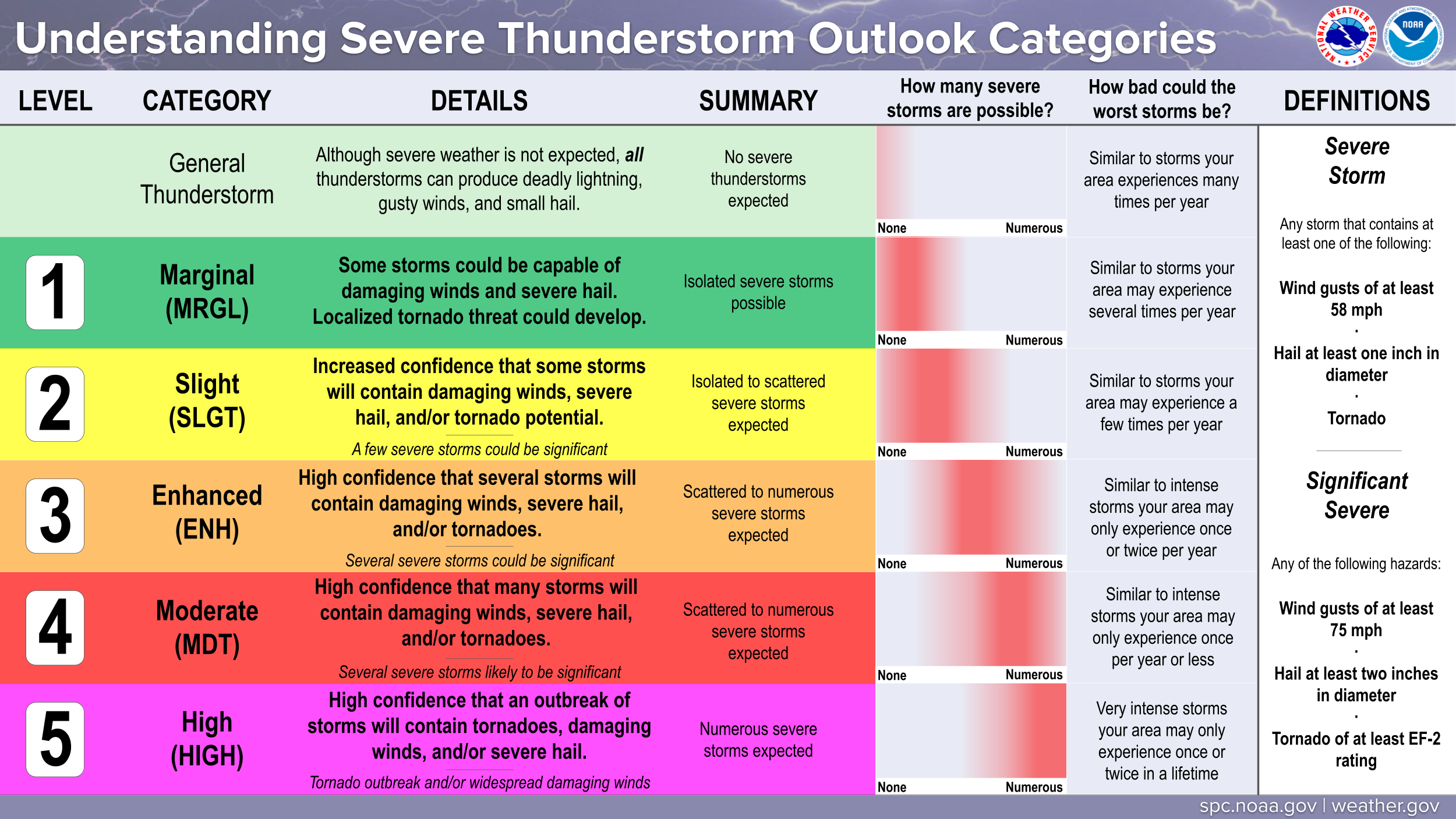
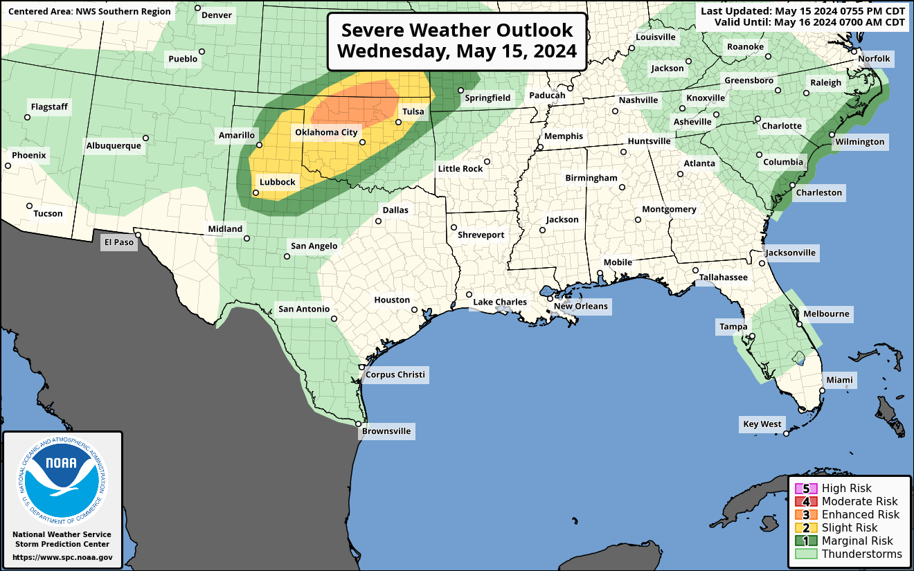
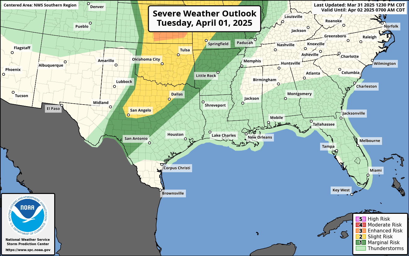
SPC Day 1 Outlook
 SPC Day 2 Outlook
 SPC Day 3 Outlook

SPC Day 2 Outlook
SPC Day 3 Outlook
Central Gulf Coast Radar Loop Western Gulf Coast Radar Loop
 Eastern Gulf Coast Radar
 East Coast Radar
 Northeast Coast Radar
 Precipitation Forecasts
Next 24 Hours QPF Total
Precipitation Forecasts
Next 24 Hours QPF Total

Next 5 days QPF Totals

Next 7 Days QPF Totals

Western Gulf Coast Radar Loop
Eastern Gulf Coast Radar
East Coast Radar
Northeast Coast Radar
Precipitation Forecasts
Next 24 Hours QPF Total
Next 5 days QPF Totals
Next 7 Days QPF Totals


Current U.S. Jetstream

SOUTHERN REGION
NOAA/NWS Storm Prediction Center Convective Outlooks
SPC Day 1 Severe Weather Outlook
 SPC Day 2 Severe Weather Outlook
 SPC Day 3 Severe Weather Outlook
 SPC Day 1 Tornado Outlook
 SPC Day 2 Tornado Outlook
 SPC Day 1 Severe Wind Outlook
 SPC Day 2 Severe Wind Outlook
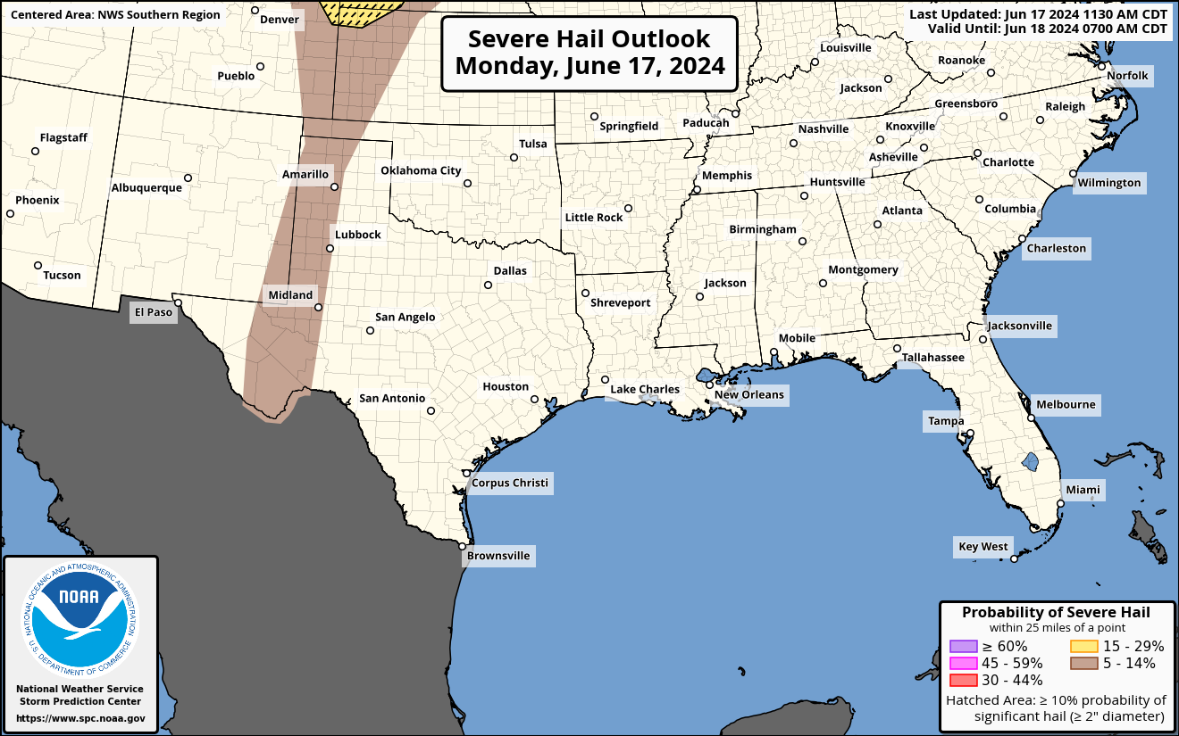
 SPC Day 1 Severe Hail Outlook
 SPC Day 2 Severe Hail Outlook

SPC Day 2 Severe Weather Outlook
SPC Day 3 Severe Weather Outlook
SPC Day 1 Tornado Outlook
SPC Day 2 Tornado Outlook
SPC Day 1 Severe Wind Outlook
SPC Day 2 Severe Wind Outlook
SPC Day 1 Severe Hail Outlook
SPC Day 2 Severe Hail Outlook
WESTERN REGION
NOAA/NWS Storm Prediction Center Convective Outlooks
SPC Day 1 Severe Weather Outlook
 SPC Day 2 Severe Weather Outlook
 SPC Day 3 Severe Weather Outlook
 SPC Day 1 Tornado Outlook
 SPC Day 2 Tornado Outlook
 SPC Day 1 Severe Wind Outlook
 SPC Day 2 Severe Wind Outlook
 SPC Day 1 Severe Hail Outlook
 SPC Day 2 Severe Hail Outlook

SPC Day 2 Severe Weather Outlook
SPC Day 3 Severe Weather Outlook
SPC Day 1 Tornado Outlook
SPC Day 2 Tornado Outlook
SPC Day 1 Severe Wind Outlook
SPC Day 2 Severe Wind Outlook
SPC Day 1 Severe Hail Outlook
SPC Day 2 Severe Hail Outlook
EASTERN REGION
NOAA/NWS Storm Prediction Center Convective Outlooks
SPC Day 1 Severe Weather Outlook
 SPC Day 2 Severe Weather Outlook
 SPC Day 3 Severe Weather Outlook
 SPC Day 1 Tornado Outlook
 SPC Day 2 Tornado Outlook
 SPC Day 1 Severe Wind Outlook
 SPC Day 2 Severe Wind Outlook
 SPC Day 1 Severe Hail Outlook
 SPC Day 2 Severe Hail Outlook

SPC Day 2 Severe Weather Outlook
SPC Day 3 Severe Weather Outlook
SPC Day 1 Tornado Outlook
SPC Day 2 Tornado Outlook
SPC Day 1 Severe Wind Outlook
SPC Day 2 Severe Wind Outlook
SPC Day 1 Severe Hail Outlook
SPC Day 2 Severe Hail Outlook
CENTRAL REGION
NOAA/NWS Storm Prediction Center Convective Outlooks
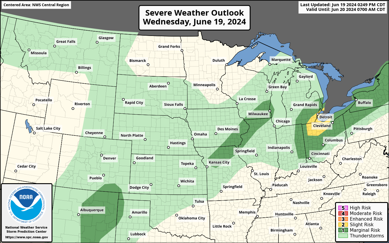
SPC Day 1 Severe Weather Outlook
 SPC Day 2 Severe Weather Outlook
 SPC Day 3 Severe Weather Outlook
 SPC Day 1 Tornado Outlook
 SPC Day 2 Tornado Outlook
 SPC Day 1 Severe Wind Outlook
 SPC Day 2 Severe Wind Outlook
 SPC Day 1 Severe Hail Outlook
 SPC Day 2 Severe Hail Outlook

SPC Day 2 Severe Weather Outlook
SPC Day 3 Severe Weather Outlook
SPC Day 1 Tornado Outlook
SPC Day 2 Tornado Outlook
SPC Day 1 Severe Wind Outlook
SPC Day 2 Severe Wind Outlook
SPC Day 1 Severe Hail Outlook
SPC Day 2 Severe Hail Outlook