51 Visitors Tracking Severe Weather!
SevereWeatherTracking.com main goal is to bring all of the important links and graphics to ONE PLACE so you can keep up to date on any threats to your area during Severe Weather!
Severe Weather Resources
- NOAA NWS Storm Prediction Center
- NOAA NWS Weather Prediction Center
- National Weather Service
- NWS Climate Prediction Center
- Chad's Track The Tropics
- Weather Nerds Model Guidance
- Twister Data Model Guidance
- Albany GFS/ EURO Models/ Ensembles
- Pivotal Weather Model Guidance
- Weather Online Model Guidance
- UKMet Model Guidance/ Analysis/ Sat
- ECMWF (EURO) Model Guidance
- WXCharts Model Guidance
- NOAA NESDIS GOES Satellite
- CyclonicWX Model Guidance
- NDMC U.S. Drought Monitoring
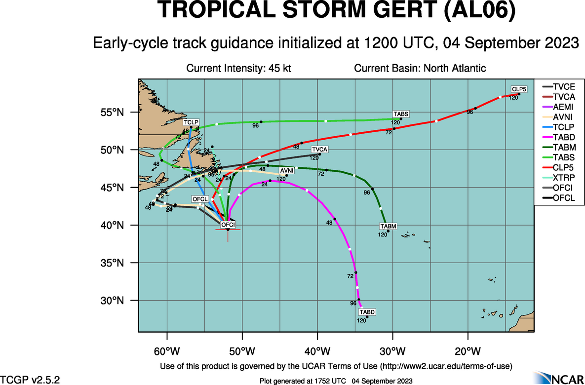
Tracking Gert – 2023 Atlantic Hurricane Season
NHC Important Links:
NHC Discussion / Public Advisory / Forecast Advisory / Wind Probs / Graphics / Storm Archive
Storm Tracking Important Links:
Wind Analysis /
Coastal Inundation Info /
Tide Information /
Surge Map /
Surge Potential /
Coastal Risk Map /
Microwave Imagery /
Advanced Dvorak ADT /
GOES16 Satellite Storm Page /
FSU Track Probability /
NOAA Tracker /
Albany Tracker /
Navy NRL Page /
HFIP Products /
Tropical Atlantic Storm Page /
NCAR Guidance Page /
CyclonicWX Tracker /
CIMSS Tracker / Tropical Tidbits Storm Page /UWM Tracker / SFWMD Models
Other Floater Sites:
TropicalTidbits - NRL Floaters - CyclonicWx - RAMMB Sat -
RAMMB Model Data -
RAMMB Wind Products
NHC Public Advisory on Gert
- Tue, 29 Sep 2026 20:33:16 +0000: Atlantic Post-Tropical Cyclone Fay Advisory Number 39 - Atlantic Post-Tropical Cyclone Fay Advisory Number 39
000
WTNT31 KNHC 292033
TCPAT1
BULLETIN
Post-Tropical Cyclone Fay Advisory Number 39
NWS National Hurricane Center Miami FL AL062026
500 PM AST Tue Sep 29 2026
...FAY BECOMES A POST-TROPICAL CYCLONE...
...THIS IS THE LAST NHC ADVISORY ON THIS SYSTEM...
SUMMARY OF 500 PM AST...2100 UTC...INFORMATION
----------------------------------------------
LOCATION...23.7N 48.2W
ABOUT 1590 MI...2560 KM WSW OF THE AZORES
MAXIMUM SUSTAINED WINDS...30 MPH...45 KM/H
PRESENT MOVEMENT...WSW OR 240 DEGREES AT 12 MPH...19 KM/H
MINIMUM CENTRAL PRESSURE...1011 MB...29.86 INCHES
WATCHES AND WARNINGS
--------------------
There are no coastal watches or warnings in effect.
DISCUSSION AND OUTLOOK
----------------------
At 500 PM AST (2100 UTC), the center of Post-Tropical Cyclone Fay
was located near latitude 23.7 North, longitude 48.2 West. The
post-tropical cyclone is moving toward the west-southwest near 12
mph (19 km/h), and this motion is expected to continue for the next
couple of days.
Maximum sustained winds are near 30 mph (45 km/h) with higher gusts.
Little change in strength is forecast, and Fay is forecast to
dissipate in a day or so.
The estimated minimum central pressure is 1011 mb (29.86 inches).
HAZARDS AFFECTING LAND
----------------------
None.
NEXT ADVISORY
-------------
This is the last public advisory issued by the National Hurricane
Center on this system. Additional information on this system can be
found in High Seas Forecasts issued by the National Weather Service,
under AWIPS header NFDHSFAT1, WMO header FZNT01 KWBC, and online at
ocean.weather.gov/shtml/NFDHSFAT1.php
$$
Forecaster Kelly
NHC Forecast Advisory on Gert
rssinpage rssfeed='http://www.nhc.noaa.gov/xml/TCMAT1.xml' rsstitlelength='50' rsstarget=’_blank’]
NHC Discussion on Gert
- Tue, 29 Sep 2026 20:34:45 +0000: Atlantic Post-Tropical Cyclone Fay Discussion Number 39 - Atlantic Post-Tropical Cyclone Fay Discussion Number 39
000
WTNT41 KNHC 292034
TCDAT1
Post-Tropical Cyclone Fay Discussion Number 39
NWS National Hurricane Center Miami FL AL062026
500 PM AST Tue Sep 29 2026
Fay's time as a tropical cyclone has faded away. An earlier
scatterometer pass showed that the system had weakened with maximum
winds around 25 kt, and that the low-level center was becoming less
defined. While occasional bursts of convection may continue, the
convection has not been organized in several hours. Thus, the system
is being designated as a post-tropical cyclone with an initial
intensity of 25 kt.
The post-tropical cyclone will continue to move generally
west-southwestward at around 10 kt, steered along the southern
periphery of the mid-level ridge located over the central Atlantic.
The system should continue to gradually weaken and is expected to
dissipate into an open trough in about a day or so. The latest NHC
track and intensity forecast is similar to the previous advisory and
lies near the latest consensus aids.
This is the last public advisory issued by the National Hurricane
Center on this system. Additional information on this system can be
found in High Seas Forecasts issued by the National Weather Service,
under AWIPS header NFDHSFAT1, WMO header FZNT01 KWBC, and online at
ocean.weather.gov/shtml/NFDHSFAT1.php
FORECAST POSITIONS AND MAX WINDS
INIT 29/2100Z 23.7N 48.2W 25 KT 30 MPH...POST-TROP/REMNT LOW
12H 30/0600Z 23.1N 49.8W 25 KT 30 MPH...POST-TROP/REMNT LOW
24H 30/1800Z 22.7N 52.0W 25 KT 30 MPH...POST-TROP/REMNT LOW
36H 01/0600Z...DISSIPATED
$$
Forecaster Kelly